Nepal Flash Floods 2026: What Happened, Damage, Safety & Travel Update
Last Updated: August 27, Nepal Flash Floods 2026
Download PDFNote: Nepal Flash Floods 2026 in August 26 flash flood in northern Nepal remains a developing disaster. Search-and-rescue operations are continuing, and casualty and missing-person figures may change as authorities reach isolated areas and verify reports. This article will be updated when significant new information is confirmed.
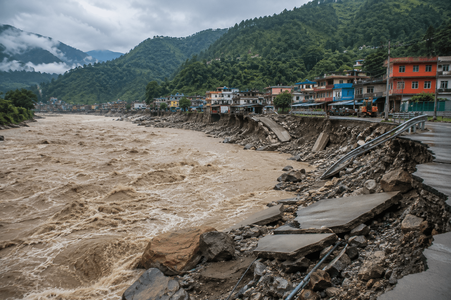
On the morning of August 26, 2026, a sudden and extraordinarily powerful flood swept through northern Nepal’s Rasuwa District, along the country’s border with Tibet. Within a short period, floodwater and debris moved through the Lhende Khola and Bhote Koshi river system, destroying roads, bridges, buildings and other infrastructure before the surge continued downstream toward the Trishuli River.
What initially appeared to be a devastating local flood quickly became a much larger regional disaster. Communities in Rasuwa and Nuwakot were severely affected, while downstream areas faced rapidly rising river levels and additional flood risks. The disaster also affected the important Nepal–China border corridor used by residents, workers, traders, tourists and pilgrims. As rescue teams continue searching for survivors and missing people, scientists are also working to understand exactly what triggered the extraordinary surge.
What Happened in Rasuwa?
The disaster began in the high Himalayan border region and rapidly affected the river corridor below.
According to the International Centre for Integrated Mountain Development (ICIMOD), water levels in the Bhote Koshi basin began rising rapidly at around 9:00 a.m. local time on August 26. The flood then breached riverbanks and traveled downstream through the Bhote Koshi toward the Trishuli River, with potential impacts extending into Nuwakot and Dhading.
Rasuwa was among the hardest-hit areas. Settlements and infrastructure around the Rasuwagadhi and Timure corridor were badly damaged, while roads and bridges that connect northern Nepal with the China border were swept away or made impassable. The damage was particularly serious because this is not an isolated mountain trail. It is an important transport and trade route and also provides access toward the Langtang region. The flood therefore disrupted both everyday life and movement through one of northern Nepal’s important Himalayan corridors.
Why Was the Flood So Powerful?
This is one of the most important questions surrounding the disaster.
At first, information circulating online suggested several possible explanations, including an earthquake, heavy rainfall, a dam failure or a glacial lake outburst. The scientific picture is becoming clearer, but the exact sequence is still being investigated. ICIMOD scientists have been investigating whether a large ice-rock avalanche in the high-altitude Lhende Khola area triggered the event. The idea is that a sudden movement of ice and rock could have entered the river system, displaced or blocked water and then produced an enormous downstream surge.
International reporting has also increasingly pointed toward a glacial or ice-related collapse and debris flow, rather than an ordinary rainfall flood. Reuters reported that the disaster was caused by a sudden collapse of ice, mud and rock into a mountain river. The important point is that the flood was not simply a case of a river gradually rising during heavy monsoon rain. The sudden movement of water and enormous quantities of rock and sediment made the event particularly destructive. That is also why some areas were hit with very little time for people to react.
From the High Himalaya to the Trishuli River
The geography of the disaster helps explain why its impact spread so far.
The suspected source area lies in the high Himalayan region around the Nepal–China border. From there, the surge entered the Lhende Khola, reached the Bhote Koshi River, and then continued into the Trishuli River system. ICIMOD has documented the downstream movement and warned of potential impacts beyond Rasuwa, including Nuwakot and Dhading. This river connection matters because communities living many kilometres away from the initial event can still be affected by a sudden upstream surge. It also explains why warnings were important along the downstream river corridor even after the worst destruction had occurred in Rasuwa.
The Human Cost
The human toll is still being established.
As of August 27, international reports were already describing the disaster as one of the most serious Himalayan flood events in recent years. Reuters reported at least 270 confirmed deaths and more than 1,000 people missing, while the Associated Press reported at least 273 deaths and more than 1,300 missing. The difference reflects the rapidly changing situation and different reporting scopes. The missing include local residents, workers, security personnel and a large number of foreign nationals.
The disaster also affected people traveling through the border region toward Mount Kailash and Lake Manasarovar, making the event particularly significant for international travelers and pilgrimage groups. Reuters reported that more than 650 foreigners were among those unaccounted for across the affected region. These figures should not yet be treated as a final death or missing-person count. Some affected locations remain difficult to reach, and authorities are still working to identify victims and locate people who may have survived but have not yet contacted their families.
The Destruction Along the River
The flood did more than cover roads with water.
It carried mud, rocks and other debris with enough force to destroy physical infrastructure along the river corridor. Homes, roads, bridges, hydropower facilities and other infrastructure were damaged. The IFRC reported that multiple bridges had been washed away and major roads disrupted, leaving some communities—particularly in Rasuwa—difficult for emergency teams to reach.
The damage to transportation is especially important because the affected road network connects communities in the mountains with markets, government services and the Nepal–China border. For residents, a destroyed bridge or road can mean much more than a travel inconvenience. It can affect access to food, medical care, communication, education and emergency assistance.
Why the Nepal–China Border Is Important
The Rasuwa–Rasuwagadhi corridor is an important connection between Nepal and Tibet.
The flood therefore affected more than isolated mountain settlements. It disrupted a route used for cross-border trade, transportation and tourism. On the Chinese side, the disaster also affected Gyirong County and the Gyirong border area. Reuters reported extensive damage and hundreds of missing people in Tibet, while Chinese authorities were also monitoring a potentially dangerous barrier lake upstream. The cross-border nature of the disaster means Nepal and China face a shared challenge: protecting communities along connected Himalayan river systems and improving communication when sudden mountain hazards occur.
Rescue Operations Are Still Underway
The immediate priority is finding missing people and reaching communities that have been cut off. Nepal has deployed security forces and emergency personnel, with helicopters being used to reach areas where roads and bridges are no longer passable. Reuters reported that more than 5,000 personnel were involved in rescue and relief operations. The humanitarian response is also underway.
The International Federation of Red Cross and Red Crescent Societies (IFRC) released nearly CHF 1 million in emergency funding for the Nepal Red Cross Society. Initial assistance includes drinking water, emergency shelter materials, blankets, sleeping mats, first-aid supplies and other essential items. The IFRC also emphasized that the true scale of the disaster will become clearer as floodwaters recede and previously inaccessible areas can be reached. The United Nations has also reported widespread destruction in Nepal and China and the deployment of humanitarian assistance.
What Happens Next?
Finding survivors is only the first stage.
Once the immediate emergency is under control, authorities will face the much longer task of restoring roads, bridges, electricity, communications and other essential services. Some communities may also need temporary shelter and longer-term support to rebuild homes and livelihoods. There is another reason the situation cannot yet be considered finished: mountain rivers can remain dangerous after the initial flood has passed.
Debris can create temporary blockages upstream, while additional rainfall can increase the risk of further flooding or landslides. Authorities and scientists are therefore continuing to monitor conditions in the affected river systems. Nepal’s Department of Hydrology and Meteorology (DHM) currently provides real-time river monitoring and flood information and advises people to use its official warnings during extreme weather.
What Does This Mean for Travelers?
This is where the story becomes especially important for people planning a trip to Nepal.
The flood does not mean that the entire country is unsafe for travel. The most serious disruption is concentrated around the affected northern river corridors, particularly Rasuwa, the Bhote Koshi area and downstream sections of the Trishuli system. Travelers heading toward the Nepal–China border should expect major disruption until authorities confirm that roads and crossings are safe. The same caution applies to people planning travel through Rasuwa and the Langtang gateway around Syabrubesi. The Nepal Tourism Board lists a Tourist Police presence in Syabrubesi, Rasuwa, but the existence of a Tourist Police post should not be interpreted as confirmation that the current road or trekking route is safe. If you have a trip planned in an affected area, check the latest road, weather and local authority information before leaving.
What About Langtang Trek?
For trekkers, this is probably one of the most important questions.
Rasuwa is the gateway to the Langtang region, so damage to roads and infrastructure around the district can directly affect access to the trekking area. That does not automatically mean that every section of the Langtang trekking route has been destroyed or that the entire region is permanently closed.
However, access conditions must be confirmed before traveling. The sensible approach right now is to wait for reliable information about roads, bridges, trail conditions, accommodation and local access rather than relying on social-media posts or old trekking information. For travelers who have already booked a Langtang trip, contact your trekking agency or local guide before departure and be prepared to postpone or change the route if necessary.
What About Everest, Annapurna and Other Trekking Areas?
It is important not to treat the Rasuwa disaster as if it affects every trekking region in Nepal equally.
Everest, Annapurna, Mardi Himal, Manaslu and other trekking destinations are geographically separate from the main Rasuwa disaster zone. That does not mean conditions are automatically perfect. August is still monsoon season, so heavy rain, landslides, road disruptions and localized flooding can affect travel in different parts of Nepal.
Safety Advice for Travelers and Local Communities
If you are anywhere near an affected river corridor, do not approach the river to take photographs or videos.
Do not cross damaged bridges, drive through floodwater or continue along roads that authorities have closed.
Even when water levels appear to be falling, riverbanks can collapse and damaged roads can give way without warning. For current flood information, the Department of Hydrology and Meteorology provides river monitoring and flood warnings through its official website. It also lists 1155 as the toll-free number for extreme weather and flood information.
International visitors who need assistance can also contact Tourist Police Nepal, which operates the toll-free tourist assistance number 1144. The Nepal Tourism Board lists Tourist Police locations across the country, including Syabrubesi in Rasuwa. Most importantly, follow instructions from local authorities rather than unverified information circulating on social media.
Is Nepal Still Open for Tourists?
Yes, Nepal as a country has not simply “closed” because of this disaster.
But some locations and routes are severely affected, and travelers should not assume that normal transportation is operating in those areas. The tourism impact is likely to be strongest in the directly affected Rasuwa and border corridor, where infrastructure damage has disrupted movement. For other destinations, travel conditions need to be considered separately. This is also why responsible travel companies should avoid telling visitors either that “everything is safe” or that “all of Nepal is dangerous.” Both statements would oversimplify the situation. Instead, travelers should check their exact route and destination shortly before departure. Only affected area is not safe but other area 95% area is safe to travel.
A Disaster That Will Be Remembered Beyond the Monsoon
The August 2026 flash flood has already become much more than a story about rising river levels.
It has exposed the vulnerability of settlements and critical infrastructure along Himalayan river corridors and shown how an event originating high in the mountains can rapidly affect communities far downstream. It has also raised important questions about how Nepal, China and other Himalayan countries monitor glaciers, unstable slopes, rivers and potential flood hazards. Scientists will need time to fully understand what happened in the high mountains and why the resulting surge became so destructive. For now, however, the priority is simpler: find the missing, help survivors, restore access and keep people away from continuing danger.
Latest Situation: August 27, 2026
The situation remains active.
Search-and-rescue teams are continuing operations in Nepal and Tibet, while authorities assess damage and attempt to account for people still missing. The latest international reports put the death toll at around 270 or more, with more than 1,000 people still missing, although individual reports differ and the numbers are expected to change as rescue operations continue. Scientists are continuing to investigate the suspected ice-rock or glacial collapse that triggered the flood, while authorities remain alert to additional hazards in the affected mountain river systems.
This article will be updated as reliable information becomes available.
Frequently Asked Questions
When did the Nepal flash flood happen?
The major flash flood struck northern Nepal on August 26, 2026, with some of the worst impacts reported in Rasuwa and along the Bhote Koshi–Trishuli river system.
What caused the Rasuwa flood?
Scientists are investigating a major ice-rock or glacial collapse in the high Himalayan region as the likely trigger. The exact mechanism is still being studied.
Which areas were affected?
Rasuwa was among the hardest-hit districts, with impacts extending downstream toward Nuwakot and Dhading along the Bhote Koshi and Trishuli river systems. The Nepal–China border area was also severely affected.
Is Langtang Trek safe right now?
Travelers should not assume that the Langtang route is currently accessible. Because Rasuwa’s road and infrastructure network has been heavily damaged, current access should be confirmed before starting the trek.
Can tourists still visit Nepal?
Yes, but travelers should assess their specific destination and route. The Rasuwa and affected river corridors require particular caution, while other parts of Nepal are geographically separate from the main disaster zone.
Where can I get official flood information?
The Department of Hydrology and Meteorology provides official flood and river monitoring information.
A Message from Attractive Travel and Tours
The recent Nepal Flash Floods 2026 have brought heartbreaking loss and severe destruction to communities in Rasuwa, Nuwakot, Dhading and other areas along the affected river corridors. At Attractive Travels and Tours, our thoughts are with the families who have lost loved ones, homes and livelihoods, as well as everyone still waiting for news of missing family members.
We deeply appreciate the efforts of the Nepal Army, Nepal Police, local authorities, rescue teams, volunteers and humanitarian organizations working around the clock to reach affected communities and provide emergency assistance. Their courage and dedication during this difficult time are helping bring hope to people facing an unimaginable situation. As a travel company working in Nepal, we understand that this disaster also creates uncertainty for visitors planning their journeys. Safety must always come before travel plans. We encourage travelers to check the latest official information before visiting affected areas, avoid restricted roads and dangerous river corridors, and remain flexible as local conditions continue to change.
It is also important to remember that the impact of this disaster is not the same across the whole of Nepal. While some northern districts and river corridors have suffered devastating damage, many other tourism destinations remain geographically separate from the affected areas. Travelers should therefore seek destination-specific information rather than assuming that the entire country is affected. Attractive Travel and Tours will continue to monitor developments and share practical information with our travelers as reliable updates become available. We stand with the affected communities and hope for the safe return of those who remain missing and a strong recovery for everyone impacted by this tragedy. Except that part Nepal is safe to travel.
Our deepest condolences to those who have lost their lives, our prayers for those still missing, and our sincere respect to everyone working to help Nepal recover. 🇳🇵